6: China’s Geography
- Modern China’s 5 historical parts
- Topography of Asia
- Continental River Basins
- Hwang Po: the Yellow River Geography
- Yangtze River Valley
Previously Chapter 8
Now that we have established the greater geographical context for the Eurasian landmass, let us return to China’s individual geography to see how this has manifested culturally. China’s geography, her body, is the soil, the earth that the human seed was planted in. Although China’s unique culture has grown from her geographical isolation, she has always been heavily influenced by outside super continental forces. Before getting into specifics let us look at China from a global perspective. Let us begin with a map of the present political boundaries of the world that surround China.
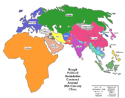
This is a map of the Eurasia-African land mass. China belongs to the Eastern Asian part of this super-continent. (We have abbreviated geographical areas to create something more relevant to China’s development. For instance the myriad countries in Europe are grouped together for simplification.)
Modern China’s 5 historical parts
Following is an even more abbreviated map that is even more relevant to China’s history. Modern day China has been broken into five parts; Turkestan, Mongolia, Manchuria, Tibet and China proper.
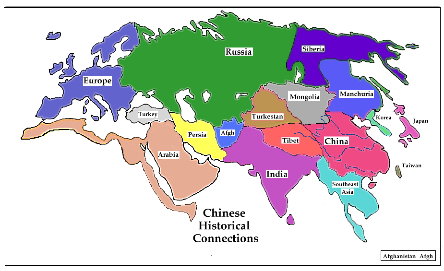
These geographical regions have never been countries, but have yielded distinct cultural differences. To understand this paper it will be helpful to understand the underlying geography.
Topography of Asia
Let us begin by looking at the topography of the region. Following is a topographical relief map of Asia. This map will prove useful in the upcoming discussions.
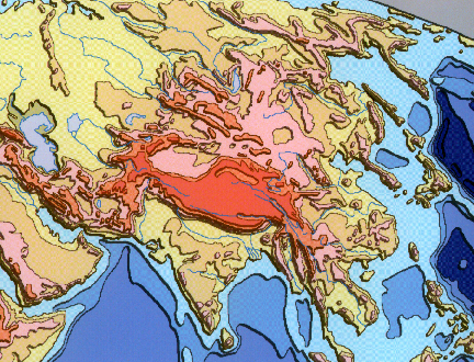
The topography of Asia has created the river basins and plateaus, which determine the traditional historical regions designated above. Notice that classic China is located in the central coastal river plain of Eastern Asia, while Tibet is located in the plateau above 12 thousand feet in altitude. Manchuria is located in a separate coastal river valley to the north, while Turkestan and Mongolia are located in plateaus of Central Asia above 3 thousand feet. These natural differences in elevation isolated the peoples of these areas, which contributed to major cultural differences.
Continental River Basins
Let us look at yet another map of the river basins of the world to further explore these differences.
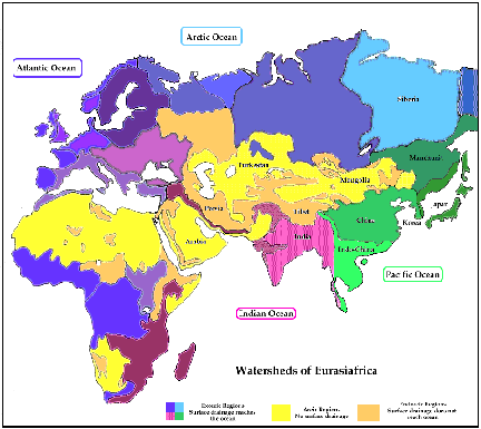
The green areas represent river valleys which feed into the Pacific Ocean, the blue the Arctic Ocean, the red the Indian Ocean, and the purple the Atlantic Ocean. These areas are further broken down into the major river basins or watersheds. The Yangtze and Yellow Rivers dominate the Chinese basin. This is the classic Chinese agricultural river valley. Southeast Asia is the Mekong River Basin, while India is the basin of the Indus and Ganges Rivers. Manchuria to the upper right is the watershed of the Amur River. Because of its northern location it has always been a heavily forested region. North of Manchuria is Siberia, whose rivers all feed into the Arctic Ocean.
Let it be pointed out that these exoreic regions, i.e. those areas whose surface drainage reaches the ocean, designated by the water drainage map, have two characteristics that they all share in common. First, a major river or rivers dominate them all. We already mentioned many of the major rivers associated with these regions. The second feature that these regions share in common is that a mountain ridge separates each basin from the other. These lines between basins indicate geographical divides which most of the time coincide with mountain ranges. These divides naturally separate climate, water, and, for the purposes of this paper, cultures. The natural elevations that separate river basins also separate flora and fauna, including the peoples and cultures of the individual basins.
An Ocean nourishes each of the aforementioned regions. Simplistically, the ocean water evaporates forming clouds, which rain and snow on the land, creating rivers and lakes, which flow back into the ocean. The ocean water evaporates creating clouds. The system repeats itself annually. An ecosystem in harmony.
Because of this fertile relationship between ocean and land, unfortunately there is no water for the land in the middle of the continent. These are shown as yellow regions to the northwest of China, which are labeled Tibet, Mongolia and Turkestan. This land gets virtually no rain because of the rain-shadow effect, whereby all water is dropped on one side of a mountain ridge leaving the other half dry. The oceans drop all their water in the adjacent river basins with nothing left for the high desert beyond. Notice that this yellow band, which indicates an areic region, i.e. an area of ‘no appreciable rainfall’, extends in a wide band into the Saudi Arabian peninsula and then into Northern Africa. This wide arid band, which extends diagonally from northeast to southwest across the Eurasia-African landmass, contains two of the largest deserts in the world, the Gobi and the Sahara and numerous smaller deserts.
The five historical regions of modern China are quite different geographically. Traditional China is an agricultural river valley; Manchuria is a northern forest; Tibet is located in a high plateau separated from the rest by the ring of the mighty Himalayas. Mongolia and Turkestan are both on the high dry desert separated from each other by distance, desert and mountains. In recent times the Communist Party of China has assumed political control of these 5 diverse geographical regions: i.e. Tibet, Turkestan, Mongolia, Manchuria, and China. The people in each of these regions speak different languages and have different customs from each other. In order to be clear in this paper, the word China refers to classic China, which only includes the agricultural river plain.
Now that we have set up the larger geographical context for the Eurasia-African landmass, let us return to China’s individual geography to see how it has affected her development.
Hwang Po: the Yellow River Geography
As pointed out earlier, China has two great rivers, the Hwang Po and the Yangtze. Basically they are separated by an extension of the Kunlun Mountain Range, the Tsinlingshan. This Himalayan finger acts as a divide for the two rivers as well as China itself. The Hwang Po, i.e. Yellow River, is the basin in the north, while the Yangtze is the river basin of the south. Their deltas merge on the coastline of China. This is called the Great China Plain. This is classic China; two merging river basins, divided by a diminishing mountain range.
The Kunlun Mountains
Both rivers originate in the high Kunlun Mountain Range. This range of mountains forms the northern side of the Tibetan Plateau. As it moves east it splits. Half continues east/west forming the Divide between the Yangtze and the Yellow River. The other half finishes circling the Tibetan Plateau in the west and then runs south to join the rugged Himalayas. Hence the Kunlun Mountains encircle China on the west and south, and also divide it into a northern and southern section. A Himalayan finger also separates China from the Mekong watershed of Southeast Asia.
Loess, nutrient rich soil from the Gobi
The North of China is the Yellow River Basin. Basically the land consists of loess, a fine yellow dirt blown from the Gobi dessert in the middle of the Arid Zone some 600 miles away. The loess forms a nutrient rich soil sometimes as much as 450 feet deep. Ironically, the earth of the Great Arid Zone is the ground of north China’s fertile agricultural river basin. Just as the wind blew the land, it also blew in the culture that was to dominate China's farmers.
The Hwang Po, an arid climate river
The Yellow River is a typical arid-climate river. There are violent fluctuations in the seasonal water flow. Because of the Yellow River’s unpredictability and because the loess, the soft fine dirt, is continually washed downstream, the shallow river is virtually useless for navigation. The Chinese have however created an enormous number of canals to channel the river’s water near the merging watersheds.
Northern Yellow River, the Edge of Chaos
The northern Yellow River flows through the southern part of the Mongolian Plateau in the Arid Zone on its way to the ocean. Hence the northern Yellow River actually defines the Pass between the nomadic Arid Zone in the north and China’s agricultural Zone of the south. This is the edge between the two civilizations.
The Hwang Po acts as a path into the North China Plain. It is logical therefore that when the Chinese wanted to separate themselves from the northern ‘barbarians’ that they would build a wall. This barrier eventually became the Great Wall. The Great Wall was built at the Pass to keep the nomadic invaders out. Thus the northern Yellow River, where the Great Wall was built, is the edge of Chaos, where nomad meets civilization.
China’s sorrow
As the Yellow River flows south and east to the ocean, it sweeps through the loess, the soft yellow soil blown from the Arid Zone. This enormous river cuts deep valleys and changes courses regularly and rapidly. Because of its strength and unpredictability, it has been nicknamed China’s Sorrow. An uncountable number of Chinese have lost their lives because of the erratic changes of the Yellow River. Within every hundred-year period in recorded history the Hwang Po has changed course at least once. Because of this unpredictability, the original settlers did not settle in the river valley, but instead settled on terraces above the valley floor. This dynamic river with its soft soil was the bed of China’s first agri-culture, as well as the center of its Empire.
Yangtze River Valley
On the edge of cultural Chaos, the Yellow River is and has always been the traditional political center of the Chinese Empire. The Yangtze River Valley, the other great Chinese river, has grown to be its agricultural center. As such we will see that it is linked with the agri-culture that eventually spawns Taoism.
China's Rice Bowl
The rice that we associate with Chinese agriculture is all grown in the moist Yangtze River Valley. Virtually none is grown in the more arid Yellow River Valley. The Yangtze River flows west to east. This might river and is blessed with strong alternating north and south running tributary rivers that originate in the surrounding mountain ridges. Thus the Yangtze River Valley is long and wide. With its many tributaries, it is perfect for the wet irrigation necessary for rice cultivation. As the rice center, it is also China's breadbasket, or in this case her rice bowl.
Trading Center
While the Yellow River is unpredictable and violent and hence unsuited to navigation, the Yangtze with its deep rivers and many tributaries is a perfect river valley for shipping. While the Yellow River can only support shipping at its mouth, the Yangtze has upwards of 20,000 miles of navigable rivers in its basin. This does not even include the myriad canals constructed in historic times. The Yangtze in addition to providing plenty of water for irrigation for the rice fields also provides transportation for the agricultural economy. The rivers of the Yangtze River Basin act as China's railway system, allowing transportation possibilities far upstream. As such, the Yangtze River Valley also acts as the trading center of China. In historic times, canals have linked the Yellow River with the Yangtze River furthering communication between the political north and the agricultural south.
Population Center
Northern China has always been the gateway for invasion. As a result, the Yellow River Basin has always been a somewhat insecure place to be. If any place is to be depopulated by warfare or famine, it is the arid Yellow River Valley of the north. Fully one half of China's population lives in the Yangtze River Basin, the other half split between the north and the south.
Cultural Center
The Chinese of the Yellow River Valley claim to be the traditional political center of imperial China. Due to their vibrant art, the south of China has always provided a major element in Chinese culture from Neolithic times. As we shall see, the connection of the south of China with the maritime and jungle cultures of Southeast Asia has provided China with the symbol of the dragon and tiger. These motifs permeate Chinese culture.
Confucian-Yellow River/ Taoist-Yangtze River
In terms of rivers, Confucianism is linked with the imperial mentality of Yellow River population. Taoism is heavily linked with the philosophies that originated in the south of China and developed in the Yangtze River Basin. Poetically speaking, the focused Yellow River with few tributaries is the homeland of the centralized political organization of the ritual-driven Chinese Empire with its Confucian philosophy. The more spontaneous and flexible philosophy associated with Taoism role-modeled after the innate logic of the multi-faceted Yangtze River Basin with all its tributaries.
Now that we have a better notion of China’s geography, it’s time to move on to her unique people.
Home China Home Page Chapters Sections Previous Next Comments