4: China’s Body
- China’s river plains
- China separated from rest of world
- Plateaus and Passes
- Mongolian Plateau and the Ordos
Previously Chapter 6
Before exploring the roots of Taoism and Confucianism, let’s examine China’s geography. This is the body of China, her foundation. In Taoist fashion we believe that the body of China has had a huge impact upon the development of her unique culture. During this discussion we will also explore the impact of the Earth’s geography upon the overall cultural development of the human species.
China’s river plains
China proper consists of three major river plains. The three rivers roughly flow from west to east, draining into the western Pacific Ocean. The Hwang-ho, the Yellow River, drains the northern quarter of China. The Yangtze River drains the middle half is and the Si Kiang, the West River drains the lower quarter.
China’s rivers originate in high mountains to the West
Each river begins in the Kunlun Mountains. These high mountains to the west separate China from India. They are categorized as ‘high relief mountains’, i.e. ‘less than 50% of the slopes are gentle and with local relief greater than 5000 feet’. They are the eastern extension of the Himalayan mountain range and are not easily penetrable due to their high relief.
China crisscrossed by mountains
China is crisscrossed by mountains going east/west and north/south. These crisscrossing mountains allow for many north-south rivers. These smaller rivers are tributaries to the larger east-west rivers. This is especially true of the Yangtze River in the middle half of China. This and its tributary rivers contain over 20,000 miles of navigable water. The Yangtze River Basin defines central China and is its most productive agricultural zone. The Yellow River Basin in the North is drier and more unpredictable. The West River basin in southern China is very irregular and quite mountainous. The smaller and less rugged east-west mountain ranges, which separate the river basins, shrink towards the coast to become part of the alluvial Great China Plain. The coast of classic China is a relatively flat delta created by the merger of the two river deltas, the Yangtze and the Yellow River.
In the topography map of China seen below, it is easily seen that the Chinese river basins begin in the Himalayas and then empty out onto a common plain. It is on this plain where the majority of the Chinese population has always lived. While the river plains of the Yangtze and the Yellow Rivers merge onto this common plain, the river plain of Si Kiang, the West River, in southern China, is separated by the Southern Uplands. This area was so geographically isolated that the inhabitants the formed their own kingdom of Nan Chao. This Tai-speaking culture was separate from the major political action of classic China until the Mongol invasion.
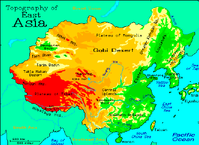
Red indicates the high altitude mountains of the Himalayas, while green indicates the low altitude coastal plains.
China separated from rest of world
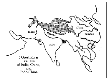
5 Major River Valleys of World originate in the Himalayas
The Himalayas define Asia. This rugged mountain uplift was presumably caused when the Indian sub-continent rammed into the Eurasian continent some 40 million years ago. The high mountain ranges are the source of an abundant water supply. Indeed five major river valleys of the world originate in the Himalayas. Starting from the west, the Indus River valley defines the western border of the Indian subcontinent, while the Ganges River valley defines the eastern border. Between the Ganges River valley and the Chinese river valleys is the Mekong River valley of Southeast Asia. Circling northward, the merging river basins of the Yangtze and the Yellow River define classic China.
These rivers are shown in the map on the map below.
A ring of mountains surround China in the south, west and north
The Himalayas and her gargantuan fingers also effectively isolate the civilizations of India, Southeast Asia, and China from each other. Rather than the ‘Himalayas’, the Chinese call their massive western border, the Kunlun Mountains. The Kunlun Mountains and its extensions enclose the enormous Chinese river basin from the west and south.
To complete their geographical isolation, the Khingan Mountains to the north almost seal China’s northern border. Unfortunately and fortunately there were two gaps left, one on the northeastern coast and the second to the north, which we will call the Pass. In this fashion, the agricultural plain of China was almost entirely sealed off from the rest of the world by these by these rugged high relief mountain ranges. This insulation combined with a few openings that allowed outside influences is why China developed an advanced and unique, culture and civilization. Let’s examine these openings.
Plateaus and Passes
More Imaginary geology
In the hundreds of thousands of years since mysterious tectonic plate collisions created the Eurasia mountain ranges, there were numerous Ice Ages, some longer and more intense than others. It seems that during the most intense of these Ice Ages that huge glaciers formed in the hollows of the mountainous land formations of Eurasia. Due to their thaws and reformation over the myriad Ice Ages, these enormous glaciers gradually hollowed out huge plateaus above coastal China. Eventually these great glaciers grew large enough to burst through the mountain ranges that surrounded China’s fertile plain. With the pulsation of these Ice Ages, Great Rivers followed the course of these ancient freedom-seeking ice rivers. Two of these great rivers are the Yangtze and the Yellow River of China. These mighty water flows merged to form the great river valley that sustained and sustains Chinese civilization.
Plateaus cursed agriculturally
The high plateaus that surround the Chinese river valley were doubly cursed agriculturally. First, the ancient glaciers scoured of them of topsoil. Second, they were subject to the rain shadow effect, which left them arid. The clouds forming over the ocean dropped all their moisture on the ocean side of the high mountains of the Himalayas, leaving none left for the high plateaus to the north. While the Indian and Chinese river valleys were perfectly suited for agriculture, the high plateaus were entirely unsuitable for this purpose.
The Openings
Where the glaciers broke through, they left a huge gap. The rivers followed the glaciers. And humans follow rivers. Except for these openings, China is surrounded by massive mountains that are virtually impassable. The glacial breaks allowed for limited interaction between the 2 diametrically opposed cultures that developed in arid high plateaus and the fertile river valleys.
The Plateaus
To the north, west and south of the Chinese river basin are three large high plateaus: the Tibetan Plateau, the Mongolian Plateau, and the Yünnan Plateau. Because of the aridity of these environments they were and are not suitable for agriculture. Nomadic groups spawned in these plateaus would regularly raid and/or invade the rich China agricultural plains. This dynamic has fueled Chinese history. As we shall see, this nomad/farmer polarity is at the root of the Chinese political history. And China’s history is heavily linked with the Confucian/Taoist polarity - based as they are upon domination and cultivation respectively.
Mongolian Plateau and the Ordos
While each plateau has supplied its own cultural dynamic, the gap between the Mongolian Plateau to the north and the Chinese River Valley has been the most significant. The relative break between the two intersecting mountain ranges is categorized as mere mountains, where the local relief is never above 5000 feet. The nomadic cultures to the north regularly traversed this opening to invade China. We will call it The Pass.
The Himalayas create a formidable natural border upon China’s western boundary. However, the high desert plateau to the north called the Mongolian Plateau is the only protection for China’s northern border. The Yellow River meanders through this high desert plateau and then finally breaks through to sweep down and fertilize China’s northern river plain. Just as the water breaks through at this point, so do invading cultures. This area where the Yellow River meanders through the high desert and then cascades to the North China plain is called the Ordos. This point of entry has leaked many invading cultures into China’s agricultural river plain. As such, this area was where the Great Wall was built as a form of protection.
The Khingan Mountains
There is one other significant break. To the east of the Mongolian Plateau are the Khingan Mountains. While the Himalayas define the western border of China’s river basin, the Khingan Mountains roughly define Manchuria’s western border with Mongolia and separate Manchuria and China. There is only one point on the coast that lacks a natural boundary. Naturally this spot was also an area of cultural leakage. Further this was the end of the Great Wall in the east and the site of continuous fortresses for thousands of years.
Home China Home Page Chapters Sections Previous Next Comments